
Papahānaumokuākea: The Northwestern Chain
Beyond Kauaʻi and Niʻihau, the archipelago continues northwest as a line of small islands, atolls, and reefs. Together with the surrounding ocean, this region is known as Papahānaumokuākea.
The name and its meaning
The name honors Papahānaumoku, the earth mother, and Wākea, the sky father, whose union is said to have created the Hawaiian islands. NOAA describes the area as a place of deep cultural importance to Kānaka ʻŌiwi, the Native Hawaiian people, who regard it as a sacred place where all life begins. The Kumulipo creation chant places the emergence of life from Pō, the primordial darkness, within this area.
The region also has a living role in navigation. A researcher quoted by NOAA calls it “a school for voyagers,” where young navigators test their skills by sailing to Nihoa. NOAA also notes significant cultural sites on Mokumanamana and Nihoa.
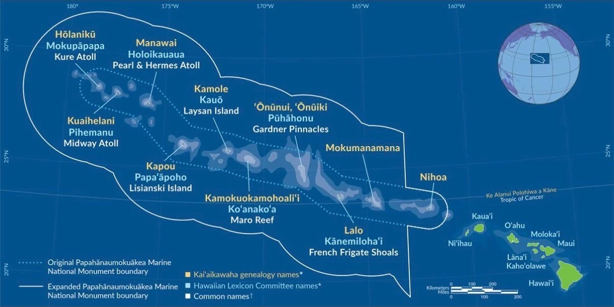
Names of the islands
Each place has more than one name. The list below follows the map above, from the northwestern end of the chain to the southeast, and adds each place’s land area from the State of Hawaiʻi land-area table.
| Common name | Kaʻiʻaikawaha genealogy name | Hawaiian Lexicon Committee name | Land area (sq mi) |
|---|---|---|---|
| Kure Atoll | Hōlanikū | Mokupāpapa | 0.333 |
| Midway Atoll | Kuaihelani | Pihemanu | — |
| Pearl & Hermes Atoll | Manawai | Holoikauaua | 0.139 |
| Lisianski Island | Kapou | Papaʻāpoho | 0.601 |
| Laysan Island | Kamole | Kauō | 1.588 |
| Maro Reef | Kamokuokamohoaliʻi | Koʻanakoʻa | Awash |
| Gardner Pinnacles | ʻŌnūnui, ʻŌnūiki | Pūhāhonu | 0.009 |
| French Frigate Shoals | Lalo | Kānemilohaʻi | 0.096 |
| Necker Island | Mokumanamana | — | 0.071 |
| Nihoa | Nihoa | — | 0.271 |
Swipe sideways to see all columns.
Names as shown on the map. The map shows a single name for Mokumanamana and for Nihoa. The State land-area table does not list Midway Atoll. Maro Reef is listed as awash, meaning it has no dry land.
Protection and recognition
- 2010. UNESCO inscribed the monument as a mixed natural and cultural World Heritage Site, the first mixed World Heritage Site in the United States.
- August 2016. The monument was expanded from 139,818 square miles to 582,578 square miles.
- January 2025. NOAA announced its decision to designate Papahānaumokuākea National Marine Sanctuary within the monument, about 582,570 square miles, to be co-managed by NOAA and the State of Hawaiʻi in partnership with the Office of Hawaiian Affairs and the U.S. Fish and Wildlife Service.
The waters hold more than 7,000 marine species, and about a quarter of them are found nowhere else but the Hawaiian archipelago.